• The Drakensberg (Afrikaans for
"Dragons Mountain")
mountains are the highest in
Southern Africa, rising up at Thabana Ntlenyana to 3,482 m (11,422
ft) in height. In
Zulu, they are referred to as uKhahlamba
("barrier of spears"), and in
Sesotho as
Maluti (also spelled Maloti ).
The Drakensberg (Afrikaans for
"Dragons Mountain")
mountains are the highest in
Southern Africa, rising up at Thabana Ntlenyana to 3,482 m (11,422
ft) in height. In
Zulu, they are referred to as uKhahlamba
("barrier of spears"), and in
Sesotho as
Maluti (also spelled Maloti ).
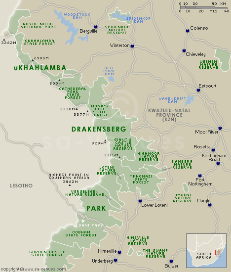
•They are located in the
eastern part of South Africa, running for some 1,000 km (600 mi)
generally southwest to northeast, with a northwesterly bend forming the northeastern border of
Lesotho with South Africa. They are drained on the west by the
Orange and
Vaal rivers, and on the east and south by a number of smaller rivers,
the
Tugela being the largest. The range thus separates
KwaZulu-Natal Province from
Free State Province, looming over the nearby coast of Natal.
•
The highest peak is
Thabana Ntlenyana at 3,482 m
(11,422 ft). It is also the highest peak of Lesotho. Other notable peaks
include Mafadi at 3,450 m,
Makoaneng at 3,416 m,
Njesuthi at 3,408 m,
Champagne Castle at 3,377 m,
Giant's Castle at 3,315 m, and
Ben Macdhui at 3,001 m. All of these are in the area bordering on
Lesotho; north of
Lesotho the range gradually becomes lower and less rugged until
entering Mpumalanga where the quartzite mountains of the Transvaal
Drakensberg are more broken and challenging to both climber and hiker.
notable peaks
include Mafadi at 3,450 m,
Makoaneng at 3,416 m,
Njesuthi at 3,408 m,
Champagne Castle at 3,377 m,
Giant's Castle at 3,315 m, and
Ben Macdhui at 3,001 m. All of these are in the area bordering on
Lesotho; north of
Lesotho the range gradually becomes lower and less rugged until
entering Mpumalanga where the quartzite mountains of the Transvaal
Drakensberg are more broken and challenging to both climber and hiker.
•Geologically, the
Drakensberg is a remnant of the original African plateau. The mountains
are capped by a layer of
basalt up to 1,500 m thick,
with
sandstone lower down, resulting in a combination of steep-sided
blocks and pinnacles. Caves are frequent in the sandstone, and many have
rock
paintings by the
Bushmen.
•Snow falls regularly in the
winter, while rains and mists can occur year-round.
• Many of the Drakensberg
peaks offer challenging
mountaineering. While the major summits have all been conquered, a
number of minor pinnacles have yet to be ascended.
Hiking is also a popular
activity. Navigation on long hikes is often aided by
GPS receivers, and current maps
distributed by KZN (KwaZulu-Natal)
Wildlife uses the
Cape datum as the
geodesic reference. GPS users should be careful to use the correct
datum as
WGS 84 is not always the default.
Many of the Drakensberg
peaks offer challenging
mountaineering. While the major summits have all been conquered, a
number of minor pinnacles have yet to be ascended.
Hiking is also a popular
activity. Navigation on long hikes is often aided by
GPS receivers, and current maps
distributed by KZN (KwaZulu-Natal)
Wildlife uses the
Cape datum as the
geodesic reference. GPS users should be careful to use the correct
datum as
WGS 84 is not always the default.
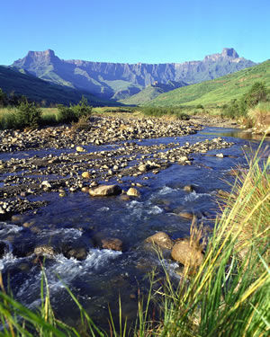
•The most well known
national park in the Drakensberg is the Royal Natal National Park where
the
Amphitheatre can be seen. It
contains the source of the
Tugela River, and includes the 947 m high
Tugela Falls, the second highest waterfall on earth. But it is the
Central Drakensberg that offers tourists the best access to bushman rock
art
Kamberg and the largest range of hiking trails.
